
Part II: How Bobo Marcos Is Losing His Father’s Kalayaan Island Group
We can bellyache all we want and throw our endless legalisms against the Chinese Coast Guard’s water cannons and green lasers, but if we continue to allow lawyers to run our lives, we will never see the end of our woes in the South China Seas.
The Municipality of Pagasa can declare the Chinese ambassador persona non grata any time, but are the people there aware that our lawyers have excised them from being part of Philippine territory? The legal surgery started in 2009.
The closest estimate is that the Pagasa (Thitu) feature is 230 nautical miles from the coast of Palawan. That means it is not also part of our exclusive economic zone, because it exceeds maximum of 200 nm.
President Ferdinand Marcos Jr. announced early, after being sworn to office, he will not lose an inch of territory.
But even before finishing his first year in office, when it became clear that he was swallowing the 2016 arbitral ruling hook, line and sinker, he is standing to lose not only an inch, but 230 square kilometers of new territorial land and 64,976 square miles (168,349 square kilometers) of territorial sea claimed in 1978 by his father Ferdinand Sr. through his Presidential Decrees 1596.
This area is comparable to the whole of Luzon.
The yawning gap was precipitated by the passage of Republic Act 9522 otherwise known as the Philippine Baselines Law, enacted on March 10, 2009 under the watch of Gloria Macapagal Arroyo.
Associate Justice Antonio Carpio was the last person who could have prevented it, but he did not. This is why in my honest opinion, I call him the “berdugo” or executioner of at least the Kalayaan Island Group.
RA 9522 amends RA 3046 and 5446, and in its Section 1 it specifically defines in 101 basepoints, the baselines of the Philippine archipelago.
The constitutionality of the law was assailed before the Supreme Court when petitioners, professors of law, law students and a legislator led by UP Professor Melvin Magallona filed a case in the Supreme Court against the government represented by Executive Secretary Eduardo Ermita, on two principal grounds, namely:
“(1) RA 9522 reduces Philippine maritime territory, and logically, the reach of the Philippine State’s sovereign power, in violation of Article 1 of the 1987 Constitution, embodying the terms of the Treaty of Paris and ancillary treaties; and
“(2) RA 9522 opens the country’s waters landward of the baselines to maritime passage by all vessels and aircrafts, undermining Philippine sovereignty and national security, contravening the country’s nuclear-free policy, and damaging marine resources, in violation of relevant constitutional provisions.”
Magallona et al asserted that from technical description passed on to us by the Americans when we acquired our independence, Philippine sovereignty over territorial waters extends hundreds of nautical miles around the Philippine archipelago, embracing the rectangular area drawn by the 1898 Treaty of Paris, and related treaties, successively encoded in the definition of national territory under the 1935, 1973 and 1987 Constitutions.
On the contrary, Section 1 of the RA 9522 limited the eastern and western extent of the Philippines as close as possible to 12 nautical miles of territorial sea from the coast of our territorial land to conform to UNCLOS, rather than demarcate the historic archipelagic nature of our country before UNCLOS was adopted in 1982 and took effect in 1994.

Note that the Philippines, as an archipelago delineated by the Treaty of Paris of1898, was reduced by a mere internal law RA 9522, changing the boundaries of Philippine territory from a rectangular-shaped one that is 600 by 1,200 nautical miles to a triangular one, leaving out around 15,000 square nautical miles or almost 50,000 square kilometers of Philippine territory.
This is only an estimate of Magallona et al. I think the accurate figure is much much more.
Considering givens, however, the Philippines being an archipelago of 7,107 islands covering 300,000 square kilometers, that is 298,170 square kilometers of land and 1,830 square kilometers of water, this shift resulted into a 15% shrinkage of the territory we inherited from the Americans.
The better strategy would have been to argue in accordance with historical rights and legality on the basis of an antecedent treaty 84 years older than UNCLOS, the archipelagic nature of the Philippines and territorial provisions enshrined in our Constitutions.
Now clearer on hindsight, the baseline law’s intention was prompted by an improvised urgency to make RA 3046 compliant with UNCLOS rather than enforce pre-existing treaty limits to which UNCLOS should be made to conform, to serve our national interest.
Losing the Kalayaan polygon
Moreover, what PD 1596 created as “part of the continental margin…” reflecting the connectivity of the Kalayaan Island Group as a polygonal archipelago attached to the larger Philippine archipelago at the limits of the Treaty of Paris, was demolished.

Section 2 of PD 9522 providing instead:
“The baseline in the following areas over which the Philippines likewise exercises sovereignty and jurisdiction shall be determined as “Regime of Islands” under the Republic of the Philippines consistent with Article 121 of the United Nations Convention on the Law of the Sea (UNCLOS):
“a) The Kalayaan Island Group as constituted under Presidential Decree No. 1596; and
“b) Bajo de Masinloc, also known as Scarborough Shoal.”
RA 9522 converted Kalayaan onto a regime of islands, from an archipelago demarcated by PD 1596 as:
“From a point [on the Philippine Treaty Limits] at latitude 7°40′ North and longitude 116°00′ East of Greenwich, thence due West along the parallel of 7°40′ N to its intersection with the meridian of longitude 112°10′ E, thence due north along the meridian of 112°10′ E to its intersection with the parallel of 9°00′ N, thence northeastward to the intersection of the parallel of 12°00′ N with the meridian of longitude 114° 30′ E, thence, due East along the parallel of 12°00′ N to its intersection with the meridian of 118° 00′ E, thence, due South along the meridian of longitude 118°00′ E to its intersection with the parallel of 10°00′ N, thence Southwestwards to the point of beginning at 7°40′ N, latitude and 116° 00′ E longitude.”
I repeat to the point of redundancy – the Municipality of Kalayaan covers an approximate area of 168,349 square kilometers of water and total land area of two hundred ninety (230) square kilometers.
Not including Scarborough as yet, this is another 35% loss of Philippine territory erstwhile claimed by President Marcos Sr.
A ‘regime of islands’ defined by the United Nations Convention of the Law of the Sea in Article 121 are islands that are naturally formed areas of land, surrounded by water, which are above water at high tide. Furthermore, this principle recognizes that each island has its own territorial sea, contiguous zone, exclusive economic zone (EEZ) and continental shelf.

The correct application would have been to enforce the PD 1596 demarcation of the latitude and longitude of Kalayaan, legally added by Marcos Sr. in 1978, four years ahead to UNCLOS adoption in 1982 and 16 years prior to its effectivity in 1994, vouchsafed as part of the continental margin of the larger Philippine archipelago, on legal, historical, and equitable grounds.
The reason advanced for the shift from polygon to a regime of islands was an objection from China, but instead of first negotiating with the Chinese, we succumbed to the pressure.
Are we suffering from some inferiority complex borne out of being a battered vassal to colonials for more than 400 years? The question is when are going to start caring for our own?

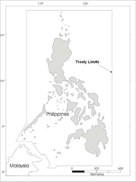
Let us now revisit the Philippine map after being mangled by the latest baselines law.
Triangular lines – the red line is according to RA 5446, amended by the blue line RA 9522.
The black rectangular line reflects limits by Treaty of Paris (1898) and the Convention Treaty between the United States and the United Kingdom (1930).
The thin black polygonal line shows the Kalayaan Island Group on the left of Palawan, connecting to the Treaty of Paris line.
All the foregoing reflects Philippine sovereignty.
UNCLOS and an Arbitration
As early as when the constitutionality of the baselines law was challenged, Magallona et al have already been issuing wake-up calls that UNCLOS was limited to the following functions – codifying norms regulating the conduct of States in the world’s oceans and submarine areas, recognizing coastal and archipelagic States’ graduated authority over a limited span of waters and submarine lands along their coasts, and a multilateral treaty regulating, among others, sea-use “rights” for maritime zones territorial waters [12 nautical miles from baselines], contiguous zone [24 nautical miles from the baselines], exclusive economic zone [200 nautical miles from the baselines], and continental shelves delimited by UNCLOS.
The green oblong line shows our claim for a 200-nautical mile Exclusive Economic Zone under UNCLOS, where under Article 56, sovereign “rights” are bestowed upon a coastal State to have the exclusivity to exploit or conserve any resources found within the water, on the sea floor, or under the sea floor’s subsoil. These resources encompass both living resources, such as fish, and non-living resources, such as oil and natural gas.
I leave it to your imagination how much wider our EEZ would have jotted out, had we not lost 50,000 square kilometers from our Treaty of Paris limits and 168,600 square kilometers from the Kalayaan Island Group.
Many, including Carpio, are misled by the word “exclusive” which even by definitions of the Convention does not mean to be absolute.
UNCLOS only bestows sovereign rights in the utilization of resources underwater. In fact, under the succeeding Article 58, all States, “whether coastal or land-locked, enjoy, subject to the freedoms referred to in Article 87 of navigation of ships and overflight, as in innocent passage, and of the laying of submarine cables and pipelines,” as well as those related to their operations.
Therefore, no country can say it “owns” its exclusive economic zone.
This debunks the slogan “What is ours is ours!” because what is not ours is not ours.
It also cannot protrude sovereign land and territorial seas of other coastal states, and in cases where EEZs overlap, coastal states must negotiate with other states how they can share its resources.
This differentiates sovereign rights from sovereignty.
As such for purposes of emphasis, UNCLOS is only a specific treaty, plays no role in defining sovereignty issues, such as acquisition, enlargement or diminution of territory.
Under general, traditional or customary international law typology, states acquire (or conversely, lose) territory through occupation, accretion, cession and prescription, not by executing multilateral treaties on the regulations of sea-use rights or enacting statutes to comply with the treaty’s terms to delimit maritime zones and continental shelves.
As I quoted in my first book A Problem for Every Solution, prominent political scientist and Emeritus Professor at The University of New South Wales, defines sovereignty as the actual occupation, administration and effective control of a given territory, and I added defense of the same if necessary.
On August 16, 2011 the Supreme Court denied the petitioners and affirmed RA 9522 under G.R No. 187167.
Carpio was the ponente of the decision.
Knowing that, I have therefore stopped to wonder why Carpio, even while still associate justice of the Supreme Court and up to now, has been lawyering for the Stratbase Albert del Rosario Institute, to the point of distorting facts and confusing the Filipino people.
Has he not yet realized his gross mistake and its deleterious consequences to our national interest? Or has he seared his conscience so much that what is left is just to cover up his tracks?
Today, the bad law continues to poison not only our positions in the South China Seas, worse our standing in the ASEAN, and worst, our bilateral relations with China, and consequently our speedy post-pandemic economic recovery.
I say it is time to unshackle our people from this bondage.
Note: This serves as Part II of an earlier article published in the AsianCenturyPH.com entitled “Antonio Carpio Escalates Lies in Esguerra Podcast”
To be continued. Next – “Sail On, Forward in the South China Seas”

Adolfo Quizon Paglinawan
is former diplomat who served as press attaché and spokesman of the Philippine Embassy in Washington DC and the Philippines’ Permanent Mission to the United Nations in New York from April 1986 to 1993. Presently, he is vice-president for international affairs of the Asian Century Philippines Institute, a geopolitical analyst, author of books, columnist, a print and broadcast journalist, and a hobby-organic-farmer.
His best sellers, A Problem for Every Solution (2015), a characterization of factors affecting Philippine-China relations, and No Vaccine for a Virus called Racism (2020) a survey of international news attempting to tracing its origins, earned for him an international laureate in the Awards for the Promotion of Philippine-China Understanding in 2021. His third book, The Poverty of Power is now available – a historiography of controversial issues of spanning 36 years leading to the Demise of the Edsa Revolution and the Forthcoming Rise of a Philippine Phoenix.
Today he is anchor for many YouTube Channels, namely Ang Maestro Lectures @Katipunan Channel (Saturdays), Unfinished Revolution (Sundays) and Opinyon Online (Wednesdays) with Ka Mentong Laurel, and Ipa-Rush Kay Paras with former Secretary Jacinto Paras (Tuesdays and Thursdays). His personal vlog is @AdoPaglinawan.

This promo includes free delivery by JRS to anywhere in the Philippines.
Email: contact@asiancenturyph.com
Facebook: https://www.facebook.com/asiancenturyph/
Twitter: https://twitter.com/AsianCenturyPH
Substack:
Also read:


Leave a Reply